 AstroNotes is migrating to a new format. Please bear with us as we complete this upgrade.
Hopefully the place will be fixed up by mid-May 2024.
AstroNotes is migrating to a new format. Please bear with us as we complete this upgrade.
Hopefully the place will be fixed up by mid-May 2024.
Two geostationary satellites captured some incredible images of an explosive eruption from an underwater volcano in the south Pacific on January 15, 2022. The event started at approximately 04:00 UT. The event was captured by NOAA’s GOES-17 West satellite and the Japanese Meteorological Agency’s Himawari-8 satellite.


Three nights ago on January 5th, I caught two comets in one imaging session. The first, Comet 156P/Russell-LINEAR, was in the constellation Triangulum. The second, Comet 398P/Boattini, was in the constellation Orion.
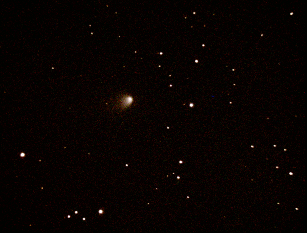
On the images posted here Comet Boattini is noticeably fainter than Comet Russell-LINEAR. Both were captured using similar exposure times and gain settings. Under these circumstances, they should appear of similar brightness. At the time, however, I was imaging Comet Boattini in comfort from inside my warm house, and failed to notice that the outside air temperature and the dew point temperature were converging near 31° F. This was serious negligence.
I didn’t realize anything was amiss until I moved on from Comet Boattini to my next target, the Pinwheel Galaxy (M101) in Ursa Major. This large galaxy fills the whole field of view of my imaging set up, but no matter how I worked the camera controls, I just couldn’t get anything better than a pale noisy ghostlike pinwheel to show up on the monitor.

After removing the dew shield the source of the problem became even more painfully obvious. The corrector plate, the large flat glass lens that covers the front end of my Schmidt-Cassegrain telescope, was completely frosted over like a heavily frosted car windshield on a cold winter morning.
Needless to say, this ended the session. But, although I was tempted, I didn’t take an ice scraper to the corrector plate.
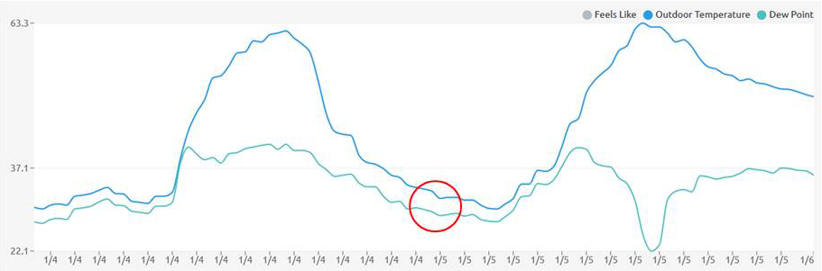
I didn’t realize it at the time, but the frosting event had already started while I was imaging Comet Boattini. This explains why Comet Boattini is fainter than Russell-LINEAR in these images despite both being at nearly the same visual magnitude.
Nevertheless, the dew shield did its job. It delayed the inevitable onset of frozen dew collecting on the optics, but it obviously was overcome by the onslaught of humidity and below-freezing temperatures and succumbed.
Having once again learned a lesson about humidity, temperature, and telescope optics I now have a telescope dew heater on order and am anxiously awaiting its arrival! There are a few months of winter left. I don’t want to get frosted again.
Notes:
[1] This animated sequence was captured with a Celestron C8 telescope (203mm f/10) operating at f/5 with a ZWO ASI224MC camera. Each of the eleven images in the sequence is made up of a stack 11-13 sub-images, or frames, each exposed for 15 seconds.
[2] This animated sequence was captured with the same equipment described in note 1. The sequence is made up of nine images, each of which consists of a stack of 11-13 frames, each exposed for 15 seconds.
December 27, 2020

This recent imagery from NOAA’s GOES-East satellite shows sunset spreading across the United States from east to west leaving a trail of sparkling lights in its wake. We can also see a major winter storm barreling across the upper midwest into the northeastern U.S. and a new storm system entering the northwest U.S. from the Pacific Ocean. Meanwhile, a large band of moisture-laden air streams into the U.S. from the Pacific and across the southern Rocky Mountains. Quite a busy but beautiful scene from the GOES-East satellite parked in its geostationary observing post 22,000 miles (36,000 km) overhead. GOES-East images are updated every five minutes. You can find the most current GOES-East imagery here. Track GOES-East (aka GOES-16) here.